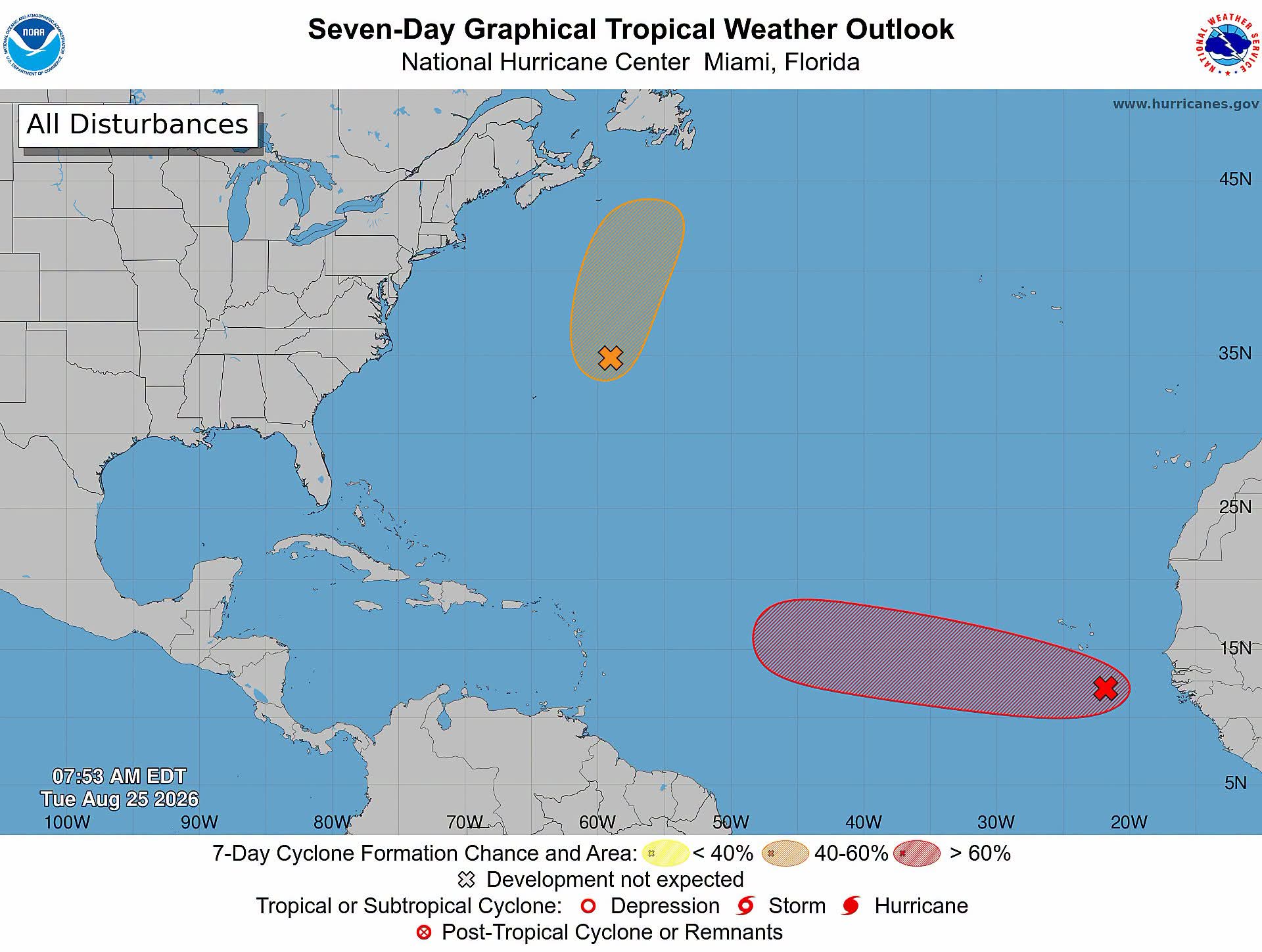
 Central Subtropical Atlantic (AL95):
An area of low pressure located a few hundred miles east-northeast of Bermuda is moving northward to north-northeastward at 15 to 20 mph. The associated shower activity remains disorganized and the circulation is broad and elongated. This system could still become a short-lived tropical depression or storm later today before encountering increasingly hostile conditions tonight and Wednesday,
likely ending its chances for development. It has a medium (40 percent) chance of formation in 48 hours and in the next 7 days.
Eastern Tropical Atlantic (AL96):
An area of low pressure centered a few hundred miles south-southeast of the Cabo Verde Islands is producing disorganized showers and thunderstorms. Environmental conditions appear conducive for gradual development, and this system is likely to become a tropical depression during the next day or two while it moves westward to west-northwestward across the eastern and central tropical Atlantic. Environmental conditions could become less conducive for development
by the weekend. It has a high (70 percent) chance of formation in 48 hours and in the next 7 days.
Central Subtropical Atlantic (AL95):
An area of low pressure located a few hundred miles east-northeast of Bermuda is moving northward to north-northeastward at 15 to 20 mph. The associated shower activity remains disorganized and the circulation is broad and elongated. This system could still become a short-lived tropical depression or storm later today before encountering increasingly hostile conditions tonight and Wednesday,
likely ending its chances for development. It has a medium (40 percent) chance of formation in 48 hours and in the next 7 days.
Eastern Tropical Atlantic (AL96):
An area of low pressure centered a few hundred miles south-southeast of the Cabo Verde Islands is producing disorganized showers and thunderstorms. Environmental conditions appear conducive for gradual development, and this system is likely to become a tropical depression during the next day or two while it moves westward to west-northwestward across the eastern and central tropical Atlantic. Environmental conditions could become less conducive for development
by the weekend. It has a high (70 percent) chance of formation in 48 hours and in the next 7 days.
Traffic & Weather
Tropical Weather Outlook

**** Via NOAA Hurricane Centre
Tropical Weather Outlook
Central Subtropical Atlantic (AL95):
An area of low pressure located a few hundred miles east-northeast of Bermuda is moving northward to north-northeastward at 15 to 20 mph. The associated shower activity remains disorganized and the circulation is broad and elongated. This system could still become a short-lived tropical depression or storm later today before encountering increasingly hostile conditions tonight and Wednesday,
likely ending its chances for development. It has a medium (40 percent) chance of formation in 48 hours and in the next 7 days.
Eastern Tropical Atlantic (AL96):
An area of low pressure centered a few hundred miles south-southeast of the Cabo Verde Islands is producing disorganized showers and thunderstorms. Environmental conditions appear conducive for gradual development, and this system is likely to become a tropical depression during the next day or two while it moves westward to west-northwestward across the eastern and central tropical Atlantic. Environmental conditions could become less conducive for development
by the weekend. It has a high (70 percent) chance of formation in 48 hours and in the next 7 days.
Central Subtropical Atlantic (AL95):
An area of low pressure located a few hundred miles east-northeast of Bermuda is moving northward to north-northeastward at 15 to 20 mph. The associated shower activity remains disorganized and the circulation is broad and elongated. This system could still become a short-lived tropical depression or storm later today before encountering increasingly hostile conditions tonight and Wednesday,
likely ending its chances for development. It has a medium (40 percent) chance of formation in 48 hours and in the next 7 days.
Eastern Tropical Atlantic (AL96):
An area of low pressure centered a few hundred miles south-southeast of the Cabo Verde Islands is producing disorganized showers and thunderstorms. Environmental conditions appear conducive for gradual development, and this system is likely to become a tropical depression during the next day or two while it moves westward to west-northwestward across the eastern and central tropical Atlantic. Environmental conditions could become less conducive for development
by the weekend. It has a high (70 percent) chance of formation in 48 hours and in the next 7 days.