 1. Near the Leeward Islands in the Tropical Atlantic:
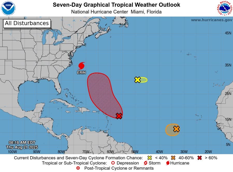
An area of showers and thunderstorms associated with a tropical wave located a few hundred miles east of the Leeward Islands has changed little over the past several hours. Environmental conditions appear conducive for further development of this system, and a tropical depression is likely to form this weekend while it moves near or to the north of the northern Leeward Islands. It has a medium (40 percent) chance of formation in the next 48 hours and a high (70 percent) chance in the next 7 days.
2. Eastern Tropical Atlantic (AL99):
Showers and thunderstorms associated with a tropical wave located several hundred miles west-southwest of the Cabo Verde Islands show some signs of organization. Environmental conditions appear marginally favorable for additional development over the next day or so while the system moves west-southwestward at around 15 mph, and a short-lived tropical depression could form. In a couple of days, environmental conditions are expected to become unfavorable for further development. It has a medium (40 percent) chance of formation in the next 48 hours and the next 7 days.
3. Central Atlantic:
A small area of low pressure located about 1200 miles southwest of the Azores is producing limited showers and thunderstorms. Upper-level winds are only marginally conducive for development while the system moves slowly eastward over the next couple of days. It has a low (30 percent) chance of formation in the next 48 hours and in the next 7 days.
1. Near the Leeward Islands in the Tropical Atlantic:
An area of showers and thunderstorms associated with a tropical wave located a few hundred miles east of the Leeward Islands has changed little over the past several hours. Environmental conditions appear conducive for further development of this system, and a tropical depression is likely to form this weekend while it moves near or to the north of the northern Leeward Islands. It has a medium (40 percent) chance of formation in the next 48 hours and a high (70 percent) chance in the next 7 days.
2. Eastern Tropical Atlantic (AL99):
Showers and thunderstorms associated with a tropical wave located several hundred miles west-southwest of the Cabo Verde Islands show some signs of organization. Environmental conditions appear marginally favorable for additional development over the next day or so while the system moves west-southwestward at around 15 mph, and a short-lived tropical depression could form. In a couple of days, environmental conditions are expected to become unfavorable for further development. It has a medium (40 percent) chance of formation in the next 48 hours and the next 7 days.
3. Central Atlantic:
A small area of low pressure located about 1200 miles southwest of the Azores is producing limited showers and thunderstorms. Upper-level winds are only marginally conducive for development while the system moves slowly eastward over the next couple of days. It has a low (30 percent) chance of formation in the next 48 hours and in the next 7 days.
Traffic & Weather
The National Hurricane Center is monitoring Hurricane Erin, located over the northwestern Atlantic Ocean

**** Via National Hurricane Centre
The National Hurricane Center is monitoring Hurricane Erin, located over the northwestern Atlantic Ocean
1. Near the Leeward Islands in the Tropical Atlantic:
An area of showers and thunderstorms associated with a tropical wave located a few hundred miles east of the Leeward Islands has changed little over the past several hours. Environmental conditions appear conducive for further development of this system, and a tropical depression is likely to form this weekend while it moves near or to the north of the northern Leeward Islands. It has a medium (40 percent) chance of formation in the next 48 hours and a high (70 percent) chance in the next 7 days.
2. Eastern Tropical Atlantic (AL99):
Showers and thunderstorms associated with a tropical wave located several hundred miles west-southwest of the Cabo Verde Islands show some signs of organization. Environmental conditions appear marginally favorable for additional development over the next day or so while the system moves west-southwestward at around 15 mph, and a short-lived tropical depression could form. In a couple of days, environmental conditions are expected to become unfavorable for further development. It has a medium (40 percent) chance of formation in the next 48 hours and the next 7 days.
3. Central Atlantic:
A small area of low pressure located about 1200 miles southwest of the Azores is producing limited showers and thunderstorms. Upper-level winds are only marginally conducive for development while the system moves slowly eastward over the next couple of days. It has a low (30 percent) chance of formation in the next 48 hours and in the next 7 days.
1. Near the Leeward Islands in the Tropical Atlantic:
An area of showers and thunderstorms associated with a tropical wave located a few hundred miles east of the Leeward Islands has changed little over the past several hours. Environmental conditions appear conducive for further development of this system, and a tropical depression is likely to form this weekend while it moves near or to the north of the northern Leeward Islands. It has a medium (40 percent) chance of formation in the next 48 hours and a high (70 percent) chance in the next 7 days.
2. Eastern Tropical Atlantic (AL99):
Showers and thunderstorms associated with a tropical wave located several hundred miles west-southwest of the Cabo Verde Islands show some signs of organization. Environmental conditions appear marginally favorable for additional development over the next day or so while the system moves west-southwestward at around 15 mph, and a short-lived tropical depression could form. In a couple of days, environmental conditions are expected to become unfavorable for further development. It has a medium (40 percent) chance of formation in the next 48 hours and the next 7 days.
3. Central Atlantic:
A small area of low pressure located about 1200 miles southwest of the Azores is producing limited showers and thunderstorms. Upper-level winds are only marginally conducive for development while the system moves slowly eastward over the next couple of days. It has a low (30 percent) chance of formation in the next 48 hours and in the next 7 days.