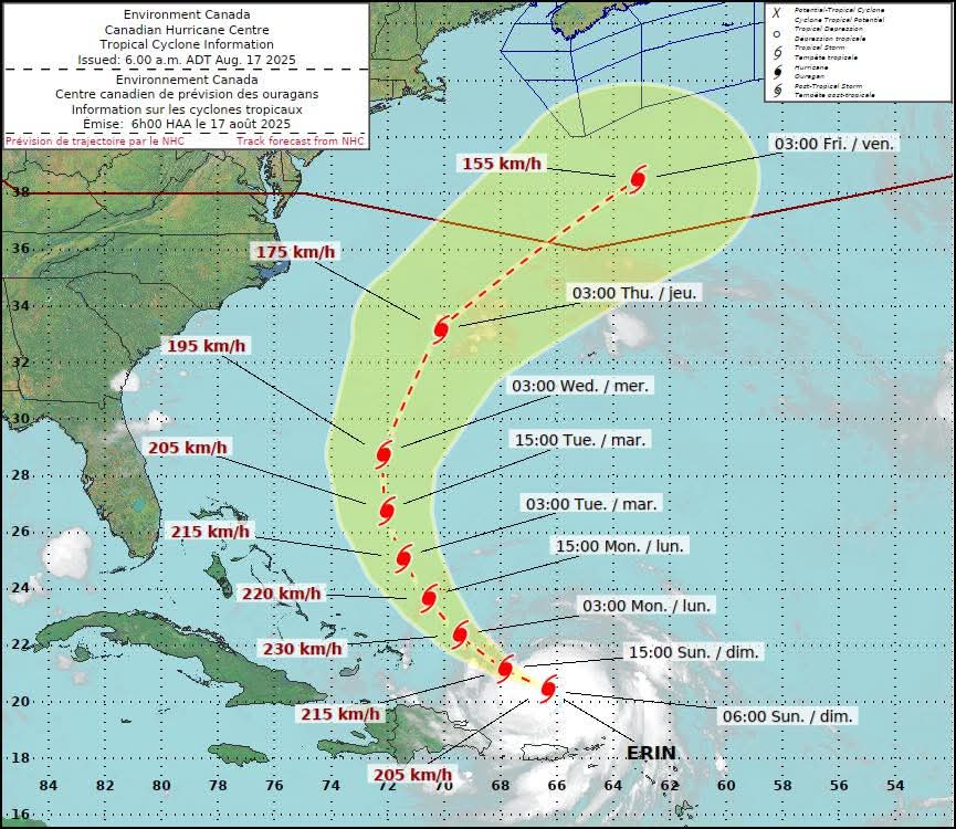
 Including Erin, there have been 43 hurricanes that have reached Category 5 status on record in the Atlantic
Earliest Reasonable Arrival Time: identifies the time window that users at individual locations can safely assume will be free from tropical-storm-force winds. Specifically, this is the time before which there is no more than a 1-in-10 (10 percent) chance of seeing the onset of sustained tropical-storm-force winds – the period during which preparations should ideally be completed for those with a low tolerance for risk.
𝐀𝐬 𝐰𝐞 𝐚𝐩𝐩𝐫𝐨𝐚𝐜𝐡 𝐭𝐡𝐞 𝐜𝐥𝐢𝐦𝐚𝐭𝐨𝐥𝐨𝐠𝐢𝐜𝐚𝐥 𝐩𝐞𝐚𝐤 𝐨𝐟 𝐭𝐡𝐞 𝐡𝐮𝐫𝐫𝐢𝐜𝐚𝐧𝐞 𝐬𝐞𝐚𝐬𝐨𝐧, 𝐢𝐭 𝐢𝐬 𝐚𝐧 𝐨𝐩𝐩𝐨𝐫𝐭𝐮𝐧𝐞 𝐭𝐢𝐦𝐞 𝐭𝐨 𝐞𝐧𝐬𝐮𝐫𝐞 𝐲𝐨𝐮𝐫 𝐩𝐫𝐞𝐩𝐚𝐫𝐞𝐝𝐧𝐞𝐬𝐬 𝐩𝐥𝐚𝐧𝐬 𝐚𝐫𝐞 𝐢𝐧 𝐩𝐥𝐚𝐜𝐞
𝐀𝐮𝐠-𝐒𝐞𝐩-𝐎𝐜𝐭 𝐚𝐫𝐞 𝐭𝐡𝐞 𝐟𝐨𝐫𝐞𝐜𝐚𝐬𝐭 𝐛𝐮𝐬𝐢𝐞𝐬𝐭 𝐩𝐞𝐫𝐢𝐨𝐝𝐬 𝐟𝐨𝐫 𝐓𝐫𝐨𝐩𝐢𝐜𝐚𝐥 𝐂𝐲𝐜𝐥𝐨𝐧𝐞 𝐅𝐨𝐫𝐦𝐚𝐭𝐢𝐨𝐧 𝐢𝐧 𝐭𝐡𝐞 𝐀𝐭𝐥𝐚𝐧𝐭𝐢𝐜
-
Including Erin, there have been 43 hurricanes that have reached Category 5 status on record in the Atlantic
Earliest Reasonable Arrival Time: identifies the time window that users at individual locations can safely assume will be free from tropical-storm-force winds. Specifically, this is the time before which there is no more than a 1-in-10 (10 percent) chance of seeing the onset of sustained tropical-storm-force winds – the period during which preparations should ideally be completed for those with a low tolerance for risk.
𝐀𝐬 𝐰𝐞 𝐚𝐩𝐩𝐫𝐨𝐚𝐜𝐡 𝐭𝐡𝐞 𝐜𝐥𝐢𝐦𝐚𝐭𝐨𝐥𝐨𝐠𝐢𝐜𝐚𝐥 𝐩𝐞𝐚𝐤 𝐨𝐟 𝐭𝐡𝐞 𝐡𝐮𝐫𝐫𝐢𝐜𝐚𝐧𝐞 𝐬𝐞𝐚𝐬𝐨𝐧, 𝐢𝐭 𝐢𝐬 𝐚𝐧 𝐨𝐩𝐩𝐨𝐫𝐭𝐮𝐧𝐞 𝐭𝐢𝐦𝐞 𝐭𝐨 𝐞𝐧𝐬𝐮𝐫𝐞 𝐲𝐨𝐮𝐫 𝐩𝐫𝐞𝐩𝐚𝐫𝐞𝐝𝐧𝐞𝐬𝐬 𝐩𝐥𝐚𝐧𝐬 𝐚𝐫𝐞 𝐢𝐧 𝐩𝐥𝐚𝐜𝐞
𝐀𝐮𝐠-𝐒𝐞𝐩-𝐎𝐜𝐭 𝐚𝐫𝐞 𝐭𝐡𝐞 𝐟𝐨𝐫𝐞𝐜𝐚𝐬𝐭 𝐛𝐮𝐬𝐢𝐞𝐬𝐭 𝐩𝐞𝐫𝐢𝐨𝐝𝐬 𝐟𝐨𝐫 𝐓𝐫𝐨𝐩𝐢𝐜𝐚𝐥 𝐂𝐲𝐜𝐥𝐨𝐧𝐞 𝐅𝐨𝐫𝐦𝐚𝐭𝐢𝐨𝐧 𝐢𝐧 𝐭𝐡𝐞 𝐀𝐭𝐥𝐚𝐧𝐭𝐢𝐜
-
What to do when a Hurricane Watch or Warning is issued / During a hurricane / Keep Your Pets Safe in an Emergency: 8 Things You Need to Know
** Release
https://waterfrontmediahfx.ca/90307-2
-
**** Via REMO Kings Cty Potential for Atlantic Tropical Cyclone formation in the next 7-days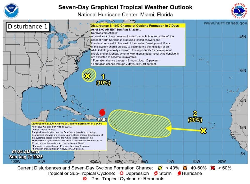 🟡 20% Central Tropical Atlantic:
Some gradual development of this system is possible during the middle to latter portion of the week while the system moves westward to west-northwestward at 15 to 20 mph across the eastern and central tropical Atlantic.
🟡 10% Northwestern Atlantic:
The opportunity for development should end on Monday when environmental upper-level wind conditions are expected to become unfavorable.
𝐀𝐮𝐠-𝐒𝐞𝐩-𝐎𝐜𝐭 𝐚𝐫𝐞 𝐭𝐡𝐞 𝐟𝐨𝐫𝐞𝐜𝐚𝐬𝐭 𝐛𝐮𝐬𝐢𝐞𝐬𝐭 𝐩𝐞𝐫𝐢𝐨𝐝𝐬 𝐟𝐨𝐫 𝐓𝐫𝐨𝐩𝐢𝐜𝐚𝐥 𝐂𝐲𝐜𝐥𝐨𝐧𝐞 𝐅𝐨𝐫𝐦𝐚𝐭𝐢𝐨𝐧 𝐢𝐧 𝐭𝐡𝐞 𝐀𝐭𝐥𝐚𝐧𝐭𝐢𝐜
🟡 20% Central Tropical Atlantic:
Some gradual development of this system is possible during the middle to latter portion of the week while the system moves westward to west-northwestward at 15 to 20 mph across the eastern and central tropical Atlantic.
🟡 10% Northwestern Atlantic:
The opportunity for development should end on Monday when environmental upper-level wind conditions are expected to become unfavorable.
𝐀𝐮𝐠-𝐒𝐞𝐩-𝐎𝐜𝐭 𝐚𝐫𝐞 𝐭𝐡𝐞 𝐟𝐨𝐫𝐞𝐜𝐚𝐬𝐭 𝐛𝐮𝐬𝐢𝐞𝐬𝐭 𝐩𝐞𝐫𝐢𝐨𝐝𝐬 𝐟𝐨𝐫 𝐓𝐫𝐨𝐩𝐢𝐜𝐚𝐥 𝐂𝐲𝐜𝐥𝐨𝐧𝐞 𝐅𝐨𝐫𝐦𝐚𝐭𝐢𝐨𝐧 𝐢𝐧 𝐭𝐡𝐞 𝐀𝐭𝐥𝐚𝐧𝐭𝐢𝐜