**** Via REMO Kings Cty
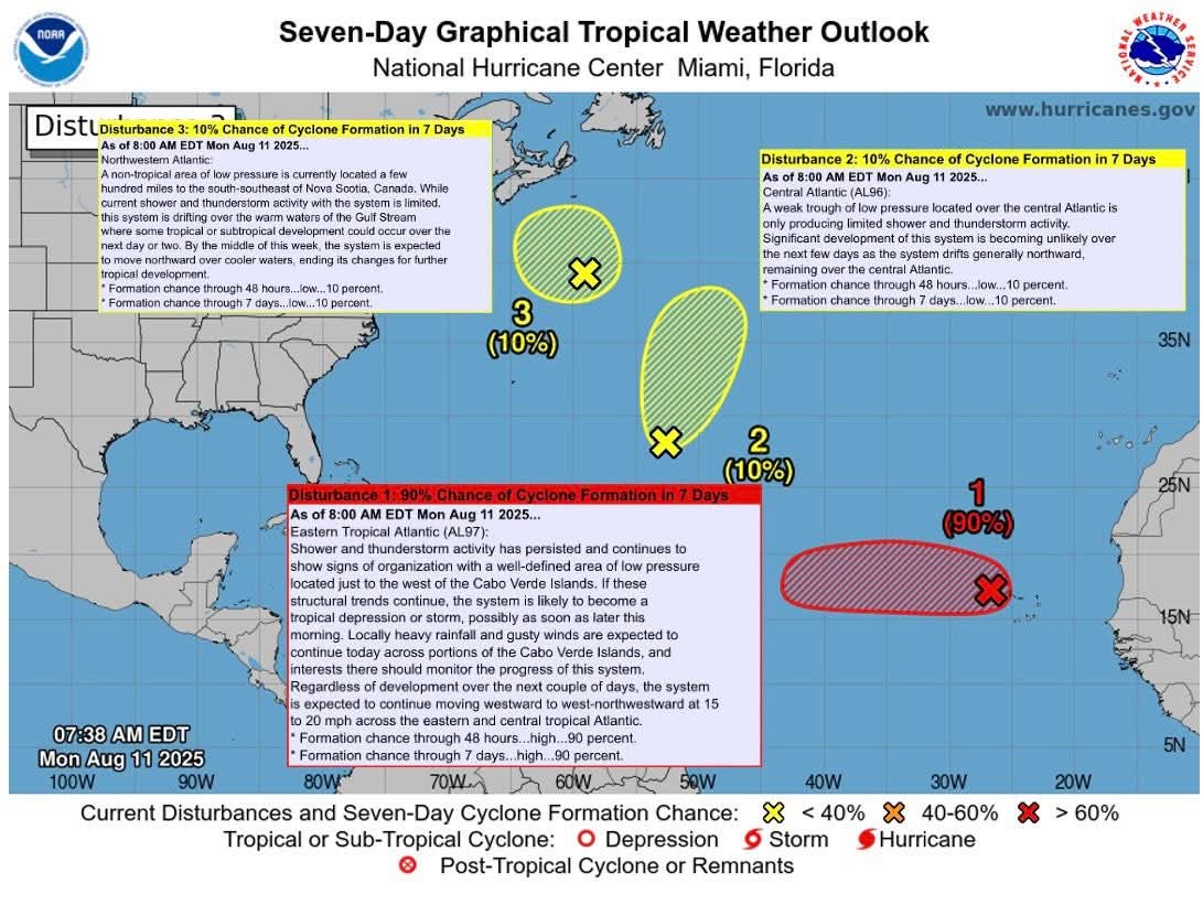
Potential for Atlantic Tropical Cyclone formation in the next 7-days

🟡 10% Northwestern Atlantic: A non-tropical area of low pressure is currently located a few hundred miles to the south-southeast of Nova Scotia, Canada. While current shower and thunderstorm activity with the system is limited, this system is drifting over the warm waters of the Gulf Stream where some tropical or subtropical development could occur over the next day or two. By the middle of this week, the system is expected to move northward over cooler waters, ending its changes for further tropical development.
🟡 20% Central Atlantic (AL96): Significant development of this system is becoming unlikely over the next few days as the system drifts generally northward, remaining over the central Atlantic.
🔴 90% Eastern Tropical Atlantic (AL97): The system is likely to become a tropical depression or storm, possibly as soon as later this morning. Regardless of development over the next couple of days, the system is expected to continue moving westward to west-northwestward at 15 to 20 mph across the eastern and central tropical Atlantic.
𝐀𝐮𝐠-𝐒𝐞𝐩-𝐎𝐜𝐭 𝐚𝐫𝐞 𝐭𝐡𝐞 𝐟𝐨𝐫𝐞𝐜𝐚𝐬𝐭 𝐛𝐮𝐬𝐢𝐞𝐬𝐭 𝐩𝐞𝐫𝐢𝐨𝐝𝐬 𝐟𝐨𝐫 𝐓𝐫𝐨𝐩𝐢𝐜𝐚𝐥 𝐂𝐲𝐜𝐥𝐨𝐧𝐞 𝐅𝐨𝐫𝐦𝐚𝐭𝐢𝐨𝐧 𝐢𝐧 𝐭𝐡𝐞 𝐀𝐭𝐥𝐚𝐧𝐭𝐢𝐜
-
What to do when a Hurricane Watch or Warning is issued / During a hurricane / Keep Your Pets Safe in an Emergency: 8 Things You Need to Know
** Release