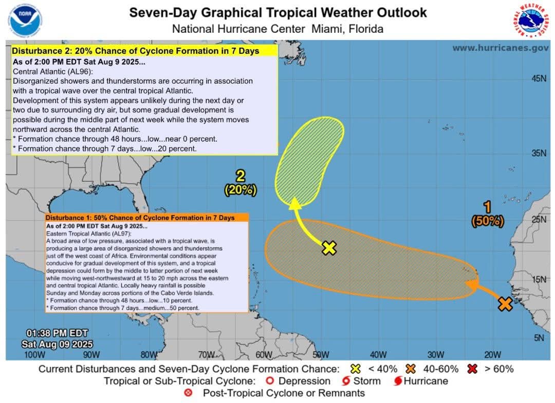
 🟡 20% Central Atlantic (AL96):
Development of this system appears unlikely during the next day or two due to surrounding dry air, but some gradual development is possible during the middle part of next week while the system moves northward across the central Atlantic.
🟠 50% Eastern Tropical Atlantic (AL97):
Environmental conditions appear conducive for gradual development of this system, and a tropical depression could form by the middle to latter portion of next week while moving west-northwestward at 15 to 20 mph across the eastern and central tropical Atlantic.
𝐀𝐮𝐠-𝐒𝐞𝐩-𝐎𝐜𝐭 𝐚𝐫𝐞 𝐭𝐡𝐞 𝐟𝐨𝐫𝐞𝐜𝐚𝐬𝐭 𝐛𝐮𝐬𝐢𝐞𝐬𝐭 𝐩𝐞𝐫𝐢𝐨𝐝𝐬 𝐟𝐨𝐫 𝐓𝐫𝐨𝐩𝐢𝐜𝐚𝐥 𝐂𝐲𝐜𝐥𝐨𝐧𝐞 𝐅𝐨𝐫𝐦𝐚𝐭𝐢𝐨𝐧 𝐢𝐧 𝐭𝐡𝐞 𝐀𝐭𝐥𝐚𝐧𝐭𝐢𝐜
🟡 20% Central Atlantic (AL96):
Development of this system appears unlikely during the next day or two due to surrounding dry air, but some gradual development is possible during the middle part of next week while the system moves northward across the central Atlantic.
🟠 50% Eastern Tropical Atlantic (AL97):
Environmental conditions appear conducive for gradual development of this system, and a tropical depression could form by the middle to latter portion of next week while moving west-northwestward at 15 to 20 mph across the eastern and central tropical Atlantic.
𝐀𝐮𝐠-𝐒𝐞𝐩-𝐎𝐜𝐭 𝐚𝐫𝐞 𝐭𝐡𝐞 𝐟𝐨𝐫𝐞𝐜𝐚𝐬𝐭 𝐛𝐮𝐬𝐢𝐞𝐬𝐭 𝐩𝐞𝐫𝐢𝐨𝐝𝐬 𝐟𝐨𝐫 𝐓𝐫𝐨𝐩𝐢𝐜𝐚𝐥 𝐂𝐲𝐜𝐥𝐨𝐧𝐞 𝐅𝐨𝐫𝐦𝐚𝐭𝐢𝐨𝐧 𝐢𝐧 𝐭𝐡𝐞 𝐀𝐭𝐥𝐚𝐧𝐭𝐢𝐜
Traffic & Weather
Potential for Atlantic Tropical Cyclone formation in the next 7-days

**** Via REMO Kings Cty
Potential for Atlantic Tropical Cyclone formation in the next 7-days
🟡 20% Central Atlantic (AL96):
Development of this system appears unlikely during the next day or two due to surrounding dry air, but some gradual development is possible during the middle part of next week while the system moves northward across the central Atlantic.
🟠 50% Eastern Tropical Atlantic (AL97):
Environmental conditions appear conducive for gradual development of this system, and a tropical depression could form by the middle to latter portion of next week while moving west-northwestward at 15 to 20 mph across the eastern and central tropical Atlantic.
𝐀𝐮𝐠-𝐒𝐞𝐩-𝐎𝐜𝐭 𝐚𝐫𝐞 𝐭𝐡𝐞 𝐟𝐨𝐫𝐞𝐜𝐚𝐬𝐭 𝐛𝐮𝐬𝐢𝐞𝐬𝐭 𝐩𝐞𝐫𝐢𝐨𝐝𝐬 𝐟𝐨𝐫 𝐓𝐫𝐨𝐩𝐢𝐜𝐚𝐥 𝐂𝐲𝐜𝐥𝐨𝐧𝐞 𝐅𝐨𝐫𝐦𝐚𝐭𝐢𝐨𝐧 𝐢𝐧 𝐭𝐡𝐞 𝐀𝐭𝐥𝐚𝐧𝐭𝐢𝐜
🟡 20% Central Atlantic (AL96):
Development of this system appears unlikely during the next day or two due to surrounding dry air, but some gradual development is possible during the middle part of next week while the system moves northward across the central Atlantic.
🟠 50% Eastern Tropical Atlantic (AL97):
Environmental conditions appear conducive for gradual development of this system, and a tropical depression could form by the middle to latter portion of next week while moving west-northwestward at 15 to 20 mph across the eastern and central tropical Atlantic.
𝐀𝐮𝐠-𝐒𝐞𝐩-𝐎𝐜𝐭 𝐚𝐫𝐞 𝐭𝐡𝐞 𝐟𝐨𝐫𝐞𝐜𝐚𝐬𝐭 𝐛𝐮𝐬𝐢𝐞𝐬𝐭 𝐩𝐞𝐫𝐢𝐨𝐝𝐬 𝐟𝐨𝐫 𝐓𝐫𝐨𝐩𝐢𝐜𝐚𝐥 𝐂𝐲𝐜𝐥𝐨𝐧𝐞 𝐅𝐨𝐫𝐦𝐚𝐭𝐢𝐨𝐧 𝐢𝐧 𝐭𝐡𝐞 𝐀𝐭𝐥𝐚𝐧𝐭𝐢𝐜