 No forecast impact to Atlantic Canada
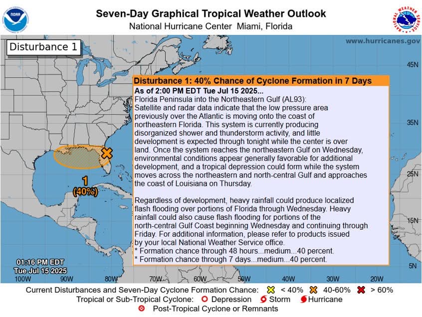
🟠 40% Florida Peninsula into the Northeastern Gulf (AL93):
Once the system reaches the northeastern Gulf on Wednesday, environmental conditions appear generally favorable for additional development, and a tropical depression could form while the system moves across the northeastern and north-central Gulf and approaches the coast of Louisiana on Thursday.
𝐀𝐮𝐠-𝐒𝐞𝐩-𝐎𝐜𝐭 𝐚𝐫𝐞 𝐭𝐡𝐞 𝐟𝐨𝐫𝐞𝐜𝐚𝐬𝐭 𝐛𝐮𝐬𝐢𝐞𝐬𝐭 𝐩𝐞𝐫𝐢𝐨𝐝𝐬 𝐟𝐨𝐫 𝐓𝐫𝐨𝐩𝐢𝐜𝐚𝐥 𝐂𝐲𝐜𝐥𝐨𝐧𝐞 𝐅𝐨𝐫𝐦𝐚𝐭𝐢𝐨𝐧 𝐢𝐧 𝐭𝐡𝐞 𝐀𝐭𝐥𝐚𝐧𝐭𝐢𝐜
No forecast impact to Atlantic Canada
🟠 40% Florida Peninsula into the Northeastern Gulf (AL93):
Once the system reaches the northeastern Gulf on Wednesday, environmental conditions appear generally favorable for additional development, and a tropical depression could form while the system moves across the northeastern and north-central Gulf and approaches the coast of Louisiana on Thursday.
𝐀𝐮𝐠-𝐒𝐞𝐩-𝐎𝐜𝐭 𝐚𝐫𝐞 𝐭𝐡𝐞 𝐟𝐨𝐫𝐞𝐜𝐚𝐬𝐭 𝐛𝐮𝐬𝐢𝐞𝐬𝐭 𝐩𝐞𝐫𝐢𝐨𝐝𝐬 𝐟𝐨𝐫 𝐓𝐫𝐨𝐩𝐢𝐜𝐚𝐥 𝐂𝐲𝐜𝐥𝐨𝐧𝐞 𝐅𝐨𝐫𝐦𝐚𝐭𝐢𝐨𝐧 𝐢𝐧 𝐭𝐡𝐞 𝐀𝐭𝐥𝐚𝐧𝐭𝐢𝐜
Traffic & Weather
Potential for Atlantic Tropical Cyclone formation in the next 7-days

**** Via REMO Kings Cty
Potential for Atlantic Tropical Cyclone formation in the next 7-days
No forecast impact to Atlantic Canada
🟠 40% Florida Peninsula into the Northeastern Gulf (AL93):
Once the system reaches the northeastern Gulf on Wednesday, environmental conditions appear generally favorable for additional development, and a tropical depression could form while the system moves across the northeastern and north-central Gulf and approaches the coast of Louisiana on Thursday.
𝐀𝐮𝐠-𝐒𝐞𝐩-𝐎𝐜𝐭 𝐚𝐫𝐞 𝐭𝐡𝐞 𝐟𝐨𝐫𝐞𝐜𝐚𝐬𝐭 𝐛𝐮𝐬𝐢𝐞𝐬𝐭 𝐩𝐞𝐫𝐢𝐨𝐝𝐬 𝐟𝐨𝐫 𝐓𝐫𝐨𝐩𝐢𝐜𝐚𝐥 𝐂𝐲𝐜𝐥𝐨𝐧𝐞 𝐅𝐨𝐫𝐦𝐚𝐭𝐢𝐨𝐧 𝐢𝐧 𝐭𝐡𝐞 𝐀𝐭𝐥𝐚𝐧𝐭𝐢𝐜
No forecast impact to Atlantic Canada
🟠 40% Florida Peninsula into the Northeastern Gulf (AL93):
Once the system reaches the northeastern Gulf on Wednesday, environmental conditions appear generally favorable for additional development, and a tropical depression could form while the system moves across the northeastern and north-central Gulf and approaches the coast of Louisiana on Thursday.
𝐀𝐮𝐠-𝐒𝐞𝐩-𝐎𝐜𝐭 𝐚𝐫𝐞 𝐭𝐡𝐞 𝐟𝐨𝐫𝐞𝐜𝐚𝐬𝐭 𝐛𝐮𝐬𝐢𝐞𝐬𝐭 𝐩𝐞𝐫𝐢𝐨𝐝𝐬 𝐟𝐨𝐫 𝐓𝐫𝐨𝐩𝐢𝐜𝐚𝐥 𝐂𝐲𝐜𝐥𝐨𝐧𝐞 𝐅𝐨𝐫𝐦𝐚𝐭𝐢𝐨𝐧 𝐢𝐧 𝐭𝐡𝐞 𝐀𝐭𝐥𝐚𝐧𝐭𝐢𝐜