Significant weather events in 2022
Top 10 Weather Events in 2022
1. Furious Fiona strikes Eastern Canada
A remarkably slow and quiet beginning to Atlantic hurricane season changed dramatically during the final week of September with the arrival of two blockbuster historic hurricanes: billion-dollar Fiona in Canada and Ian in the United States. Fiona began as a tropical depression on September 14 over the warm waters of the central Caribbean. As a Category 1 hurricane, Fiona brought torrential rains, flash flooding and powerful winds to Puerto Rico and the Dominican Republic before strengthening to Category 3 and becoming the first major hurricane of the season. East of the Bahamas, Fiona reached Category 4. Twelve days later and 4 000 km away, Fiona finally dissipated in the Labrador Sea over much cooler waters, after leaving a path of destruction all the way from the Virgin Islands to Eastern Canada. On September 22, a separate mid-latitude storm stretching from Hudson Bay to Labrador brought wet weather. At the same time, Fiona grew larger, with its strong winds and heavy rains spreading well away from the storm’s centre to an expansive 800 km diameter. Over the next two days, the storms quickly merged into an extremely powerful post-tropical system with characteristics of both a strong hurricane and a strong fall cyclone. Although Fiona morphed into a post-tropical system before landfall, the storm lost little of its strength by the time it arrived in Canada. During the early morning hours of September 24, Fiona made landfall in eastern Nova Scotia with sustained winds of 165 km/h at hurricane-force 2. It arrived with a minimum pressure of 932.7 millibars near the eye, the deepest barometric pressure for a storm ever recorded over land in Canada. The reading smashed Canada’s previous all-time sea-level pressure record at 940.2 millibars from 1977 and was on par with past violent hurricanes such as Sandy and Andrew. The storm continued north across Cape Breton during the pre-dawn hours of September 24 and then over the cooler waters of the Eastern Gulf of St. Lawrence to southwest Newfoundland during the day. The storm finally reached Quebec’s Lower North Shore early on September 25 before racing across southeastern Labrador and spinning out over the Labrador Sea later that day. Fiona pounded Atlantic Canada with heavy rains, powerful winds, mighty storm surges and incredibly high waves. Rainfall of 80 to 150 mm or more occurred across the Maritimes and eastern Quebec. At its peak, the storm’s rainfall rates exceeded 30 mm per hour, triggering flash flooding with ponding and washouts. Fast-moving waters flooded everywhere, filling basements, collapsing roads, overwhelming culverts, triggering landslides, slumping soil, and eroding road beds. Significant storm surges reaching nearly two metres caused extensive coastal damage and erosion, particularly on the beaches at Prince Edward Island’s Cavendish-North Rustico, Brackley-Dalvay and Greenwich, in the Northumberland Strait and on parts of Cape Breton’s east coast, Mainland Nova Scotia and southwestern Newfoundland. Giant walls of water came ashore, causing significant coastal erosion that will take decades to heal. A buoy over Banquereau Bank (east of Cape Breton) recorded waves averaging 12 to 15 metres, with peak waves reaching an astonishing 30 metres.
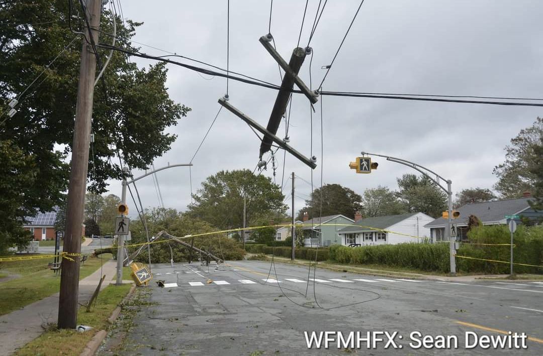
Fiona’s strongest winds of 179 km/h were felt along Nova Scotia’s North Shore, and the western and southwestern parts of Newfoundland and Labrador topped 177 km/hour in the Wreckhouse area. Wind gusts exceeding 100 km/h occurred in five provinces and lasted 6 to 12 consecutive hours. Fully leafed trees created added stress and soft ground from previous rains made trees easy marks for storm winds. Power poles and century-old trees toppled like dominos, while relentless winds and the powerful storm surge damaged and destroyed homes and buildings, transforming coastal geography. Fiona left streets, beaches and parks littered with downed branches and foliage. There were structural losses and considerable coastal infrastructure damage to wharves, piers and breakwaters. Strong winds ripped roofs from homes in some areas. Fiona’s fury also claimed several natural tourism landmarks such as heritage trees, rock formations, statues and popular geographic features.
In Quebec, the Magdalen Islands were the hardest hit: peak wind gusts reached 132 km/h. The Island faced 37 evacuations, closed roads and declared a state of emergency. On September 25, the eastern end of Anticosti Island as well as the Lower Shore of Québec from Minganie to Blanc-Sablon were soaked with 80 mm rains, lashed by winds of 100 km/h and pounded by 10 metre waves. Homes, cottages and boats were damaged and trees uprooted; in some cases, cottages and outbuildings were blown off their foundations.
Utility workers in Atlantic Canada, aided by crews from Ontario, Quebec and Maine, faced the herculean undertaking of repairing electrical transmission and distribution systems. Falling trees knocked out power to more than 600 000 homes and businesses, some having to endure outages for more than two weeks. The impacts were large and immediate and it will take months if not years to clean up and restore infrastructure over five provinces. Nearly 1000 soldiers and military engineers of the Canadian Armed Forces moved in to help start the process.
Thanks to particularly accurate long-range forecasts and warning, residents were able to prepare for the storm by tying down outdoor furniture and stocking up on groceries, flashlights and batteries while work crews cleared culverts and catch basins.
Fiona was a large-scale, high-impact storm and likely the most damaging hurricane in Canadian history. Tragically, there were three storm-related deaths associated with the storm. Fiona’s unusually slow forward speed contributed greatly to the destruction. To date, insurance losses come in at $846 million.

2. Billion-dollar derecho rakes across Ontario and Quebec
Just before the May long weekend, two days of intense heat and humidity propelled a hugely powerful line of storms across central Ontario and Quebec, bringing torrential rains, large hail and frequent lightning. However, it was the swath of downburst winds that resulted in the most damage. Meteorologists call this kind of system a derecho - a group of thunderstorms that move in a straight line much like the frontline of advancing soldiers in a battlefield. Derechos can cause as much damage as a hurricane or tornado but usually cover a larger area than a tornado. For the first time in Environment and Climate Change Canada’s weather service’s history, it issued a broadcast immediate severe thunderstorm alert through the National Public Alerting System (Alert Ready), as a means of directly reaching those close to the affected region through their mobile devices, radios and televisions. These alerts are issued only when an observed thunderstorm meets the criteria for a life-threatening storm. People were urged to take immediate shelter. Around noon on May 21, the skies turned from bright and sunny to dark and foreboding. The storm cluster moved quickly, traversing 1 000 km from Sarnia to Quebec City in nine hours with damage over 100 km wide. Strong upper-level winds blew down into the storm's centre, pushing horizontal straight-line winds forward. Embedded at the leading edge of the system was a tornado that touched down in Uxbridge with a maximum wind speed of 195 km/h. Two other tornadoes were documented south of London. One intense downburst in south Ottawa had velocities of 190 km/h. Whereas Ontario and Quebec have seen derechos before, this was one of the few in memory that raced through major cities. The derecho travelled along the Highway 401 corridor through Ottawa before crossing into Quebec. Montreal was mainly spared as the storm moved east from Ottawa and north of the St. Lawrence River towards Trois-Rivières, Quebec City and the Eastern Townships. Winds broke branches and sometimes yanked entire trees out of the ground, exposing their roots. Winds easily took out entire lines of trees, blocking roads and slowing traffic. Hundreds of thousands of majestic, mature shade trees, some 100-years-old, were lost to the storm. Winds turned loose objects into flying projectiles, overturned vehicles, tore down construction scaffolding and ripped shingles off roofs. Countless homes and porches were cracked, bent and broken by falling trees. Passengers on trains, airlines and transit services faced hours-long delays due to downed power lines and live wires across roads and tracks. In rural areas, winds flattened 100-year-old barns, took down silos, tossed around farm equipment and flattened early crops. More than a million hydro customers across Ontario and Quebec were left without power. A week later power was still out for nearly 30 000 homes. Ottawa Hydro claimed the damage and disruption to the hydro system was worse than the ice storm of January 1998 and the swarm of tornadoes in September 2018. Tragically, 11 people died in the aftermath, mostly by fallen trees. At least 13 communities declared states of emergency, including the towns of Uxbridge and Clarence-Rockland, east of Ottawa. The storm resulted in more than a million insurance claims, topping one billion dollars in damages, making it the sixth largest in terms of insured losses in Canadian history.3. Manitoba’s drenching spring
At the midway point of the 2022 flood season, flow along the Red River in southern Manitoba didn’t appear to be a threat. However, by May 1, following a parade of five wet Colorado low systems, Manitoba faced some of its most extensive, longest-lasting flooding in years. The Pembina, Assiniboine, Souris, Fisher, Roseau, Rat, Winnipeg and Red Rivers were all at risk of overflowing. Over the winter, most areas of southern Manitoba saw upwards of 150 cm of snow, making it the third-highest snowfall since 1872. In spring, Winnipeg recorded a total of 331.4 mm in precipitation, making it the wettest on record (the previous record of 325.4 mm was set in 1896). It was also 3.6 times the 30-year normal, a quantity unseen since records began in 1872. Record amounts of snow and rain fell in April and May, streaming in at 30 to 60 mm at a time. Because this happened when most of the ground was still frozen and saturated with water, the soil was unable to absorb the high intensity, short duration rainfall. Strong wind gusts up to 80 km/h only worsened the flooding, causing water levels on lakes and fields to rise and overflow onto roads and erode dikes. Water levels on the Red River approached those of the 2009 flood, the highest since the 1997 flood of the century. And in 2022, the river crested with its sixth-highest volume since record keeping began. At the peak of the flooding, 45 municipalities and nine First Nation communities across the province declared local states of emergency due to churned up and washed-out roads, swollen ditches, flooded properties and damage to water treatment infrastructure. Residents everywhere were busy operating water pumps, inspecting dikes and filling sandbags. Floodwaters surrounded entire towns. The province closed provincial parks, campgrounds, and hiking trails. Soggy grounds forced the cancellation of sporting practices, games and tournaments for weeks. More than 1 000 residents of Peguis First Nation were forced to flee their homes amid severe flooding and an ice jam, the worst since 2000. Manitoba has a long history of spring flooding, but in 2022, it came from clusters of back-to-back wet days. People dealt with flood fatigue, stress and burnout amid a disaster that dragged on for eight weeks. The geographic scale of this year's flooding was unprecedented; a result of several high yielding storms, rather than from a single snowmelt or a single storm event like in 1997. While perhaps not the worst in history, the extent and duration of the flood certainly felt historic with flood-related cost estimates nearing $10 million.
4. Return to hot and dry weather under the dome
Summer 2022 was the third warmest Canadian summer on record, eclipsed only by 2012 and 1998. Across the country it was consistently warm – almost 1.6°C above normal. In many places, the summer-like weather stretched over five or six months– from May into October in some, and from July to November in others. In 2021, it was May to July warmth for western Canada under the infamous heat dome. This year the blocking dome returned to the West from late August to October. In the East, a stationary high pressure kept summer going until mid-November. Many weather sites in the West broke century-long records for the warmest August to October period on record. Because of the abnormally cool, wet spring, farmers were especially grateful for the incredible harvest weather beyond Thanksgiving that helped balance what had been a record late start to the growing season.In the West
A sprawling and unusually persistent dome over the western half of North America, often referred to a sub-tropical Hawaiian high-pressure ridge, was responsible for the long stretch of record-setting heat across both sides of the border. Excessive heat watches and warnings affected millions of North Americans across three provinces, three territories and eight states. While this high-pressure heat dome was less intense than last year’s prevailing weather, it lasted several weeks longer. The immense area of dryness across western North American contributed to the Northern Hemisphere drought. From mid-August to mid-October, more than 500 maximum daily temperature records were surpassed over 70 days. British Columbia had one of the hottest Augusts on record. Lytton, where a national all-time high temperature tragically wreaked widespread devastation in 2021, again topped out with a high of 39.6°C on September 2. This was the highest temperature ever observed in British Columbia during the month of September. Emergency water limits affected heavy commercial water users such as breweries, water bottlers, concrete and cement companies, and cannabis growers. Farm animals and crops suffered as irrigation halted. Drought pushed trees to the edge of dying, causing fears that they would topple in winter windstorms. Limits were imposed on sprinkling gardens and there were widespread bans on filling swimming pools, washing cars and boats. Millions of residents and commercial customers were asked to conserve precious treated drinking water, including by taking shorter showers. The drought and heat challenged BC’s power-generating system and caused issues for managing dwindling water supplies from and into reservoirs. With temperatures hitting 38°C in the southern part of Alberta and Saskatchewan, August was one of the hottest months on record for the province. The warmth carried over into September, where Medicine Hat recorded a high of 38.3°C on September 3– the community’s hottest September day in the books. Nearby in Swift Current, the temperature soared to 36.4°C, smashing another monthly record. After the third warmest summer in 75 years, Alberta’s fall was dry and smoky. Albertans used to cooler and snowier falls would be likely to think the weather felt much more like June than October. It wasn’t just hot; it was record dry too. From July 19 to October 19, British Columbia was North America’s dry spot. In Vancouver, only 13 mm of rain fell. This was in contrast to the normal total of 176 mm and 2021’s total of 294 mm for the same timespan. The situation was worse in Victoria, where there was less than 2 mm of rain compared to the normal 120 mm. This made it the driest period for the city since records began in 1898. Renowned dry cities such as Las Vegas, Los Angeles and Phoenix received more rain in these 100 days than Vancouver Island, the Lower Mainland and the Gulf Islands. The combination of record long heat and dryness had enormous impacts on almost every aspect of the economy and the environment across northern and western Canada. The persistent warmth and dryness kept the wildfire season active up to nine weeks longer than normal. Skies were stale and smoky for 12 weeks beyond the peak of forest fire season. With little or no rain for eight weeks, rivers and streams started drying up. With a dwindling water supply, it became too hot for fish to survive and oxygen depletion led to a massive die-off of thousands of salmon returning to stream along coastal rivers and streams. The extensive and enduring drought prompted several communities, desperate for rain, to declare states of local emergency, especially on the Sunshine Coast. Adding to the anxiety and unbearable heat, millions of residents and business were forced to conserve drinking water and observe strict restrictions.In the East
Eastern Canada saw a bonus four weeks of summer warmth, with ample sunshine, light winds and little rain between Thanksgiving and Remembrance Day. In November across the East, more than 200 heat records were set and many daytime highs exceeded 20°C. St. Catharines, ON, St. Anicet, QC, Fredericton, NB and Kentville, NS, all recorded their all-time warmest temperatures for the month. The odd foggy morning couldn’t spoil nature’s gift. It was another high-pressure ridge known as a Bermuda High, a semi-permanent feature that became established farther north and west than its summer position, that continued to pump southern air northward. In Atlantic Canada, sea-surface temperatures were also 3 to 4 °C warmer than normal. This was no one- or two-day warm spell, but a glorious four-week stretch that residents could not recall happening before so late in the year. Crowds flocked to parks, waterfronts and golf courses to enjoy September temperatures in November. Nature seemed confused and awakened to growing again. Many Easterners, pleased with the extended summer, hoped that it might mean a shorter than normal winter.