 -
Special weather statement
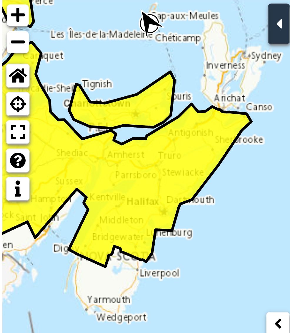
Snow and strong winds are expected this evening and overnight.
Potential snowfall: 10 to 15 cm
Potential wind gusts: north to northeasterly 60 to 80 km/h.
Time span: beginning this evening and ending Monday morning.
Impacts: Travel conditions will gradually deteriorate this evening due to accumulating snow, strengthening winds and blowing snow.
Remarks: Recent computer guidance has trended eastward and snowfall warning criteria is not expected but significant snowfall is still likely. The snow will be accompanied by reduced visibility in blowing snow over exposed areas.
-
Coastal flooding statement
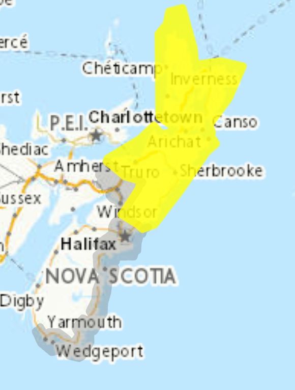
This statement is in effect for parts of the coast due to the following hazard(s): Very high tides. Higher than normal water levels.
Locations: Yarmouth County to Halifax County.
Time span: Monday morning near the high tide.
Remarks: A pronounced storm surge occurring with high tide has the potential to raise water levels well above the highest astronomical tide.
Coastal erosion may occur in vulnerable locations.
Avoid affected shorelines where hazardous conditions may develop.
People in coastal areas should monitor conditions closely in case they begin to worsen.
Please continue to monitor alerts and forecasts issued by Environment Canada. To report severe weather, send an email to NSstorm@ec.gc.ca or post reports on X using #NSStorm.
-
Source
https://weather.gc.ca/index_e.html?alertTableFilterProv=NS¢er=45.31494251,-63.18863920&zoom=5
-
Special weather statement
Snow and strong winds are expected this evening and overnight.
Potential snowfall: 10 to 15 cm
Potential wind gusts: north to northeasterly 60 to 80 km/h.
Time span: beginning this evening and ending Monday morning.
Impacts: Travel conditions will gradually deteriorate this evening due to accumulating snow, strengthening winds and blowing snow.
Remarks: Recent computer guidance has trended eastward and snowfall warning criteria is not expected but significant snowfall is still likely. The snow will be accompanied by reduced visibility in blowing snow over exposed areas.
-
Coastal flooding statement
This statement is in effect for parts of the coast due to the following hazard(s): Very high tides. Higher than normal water levels.
Locations: Yarmouth County to Halifax County.
Time span: Monday morning near the high tide.
Remarks: A pronounced storm surge occurring with high tide has the potential to raise water levels well above the highest astronomical tide.
Coastal erosion may occur in vulnerable locations.
Avoid affected shorelines where hazardous conditions may develop.
People in coastal areas should monitor conditions closely in case they begin to worsen.
Please continue to monitor alerts and forecasts issued by Environment Canada. To report severe weather, send an email to NSstorm@ec.gc.ca or post reports on X using #NSStorm.
-
Source
https://weather.gc.ca/index_e.html?alertTableFilterProv=NS¢er=45.31494251,-63.18863920&zoom=5
Traffic & Weather
A special weather statement and coastal flooding statement is in effect

**** Via Environment Canada
A special weather statement and coastal flooding statement is in effect
-
Special weather statement
Snow and strong winds are expected this evening and overnight.
Potential snowfall: 10 to 15 cm
Potential wind gusts: north to northeasterly 60 to 80 km/h.
Time span: beginning this evening and ending Monday morning.
Impacts: Travel conditions will gradually deteriorate this evening due to accumulating snow, strengthening winds and blowing snow.
Remarks: Recent computer guidance has trended eastward and snowfall warning criteria is not expected but significant snowfall is still likely. The snow will be accompanied by reduced visibility in blowing snow over exposed areas.
-
Coastal flooding statement
This statement is in effect for parts of the coast due to the following hazard(s): Very high tides. Higher than normal water levels.
Locations: Yarmouth County to Halifax County.
Time span: Monday morning near the high tide.
Remarks: A pronounced storm surge occurring with high tide has the potential to raise water levels well above the highest astronomical tide.
Coastal erosion may occur in vulnerable locations.
Avoid affected shorelines where hazardous conditions may develop.
People in coastal areas should monitor conditions closely in case they begin to worsen.
Please continue to monitor alerts and forecasts issued by Environment Canada. To report severe weather, send an email to NSstorm@ec.gc.ca or post reports on X using #NSStorm.
-
Source
https://weather.gc.ca/index_e.html?alertTableFilterProv=NS¢er=45.31494251,-63.18863920&zoom=5
-
Special weather statement
Snow and strong winds are expected this evening and overnight.
Potential snowfall: 10 to 15 cm
Potential wind gusts: north to northeasterly 60 to 80 km/h.
Time span: beginning this evening and ending Monday morning.
Impacts: Travel conditions will gradually deteriorate this evening due to accumulating snow, strengthening winds and blowing snow.
Remarks: Recent computer guidance has trended eastward and snowfall warning criteria is not expected but significant snowfall is still likely. The snow will be accompanied by reduced visibility in blowing snow over exposed areas.
-
Coastal flooding statement
This statement is in effect for parts of the coast due to the following hazard(s): Very high tides. Higher than normal water levels.
Locations: Yarmouth County to Halifax County.
Time span: Monday morning near the high tide.
Remarks: A pronounced storm surge occurring with high tide has the potential to raise water levels well above the highest astronomical tide.
Coastal erosion may occur in vulnerable locations.
Avoid affected shorelines where hazardous conditions may develop.
People in coastal areas should monitor conditions closely in case they begin to worsen.
Please continue to monitor alerts and forecasts issued by Environment Canada. To report severe weather, send an email to NSstorm@ec.gc.ca or post reports on X using #NSStorm.
-
Source
https://weather.gc.ca/index_e.html?alertTableFilterProv=NS¢er=45.31494251,-63.18863920&zoom=5