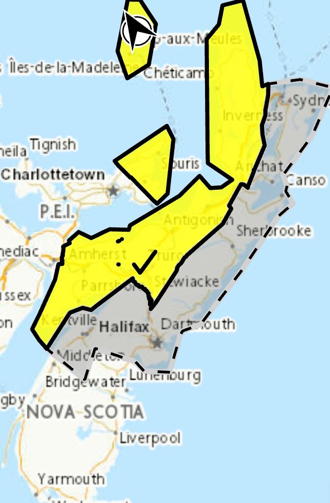
 A complex wintry mix of weather is expected. Snow is forecast to intensify tonight.
Locations: Kings, Hants, Halifax, Guysborough, Richmond, and Cape Breton Counties.
Potential snowfall: 10 to 15 cm, possibly more inland and over high terrain.
Total rainfall: 15 to 20 mm in some coastal areas.
Time span: today through Monday morning.
Remarks: Flurries this morning will give way to periods of rain in coastal areas of Cape Breton and the eastern shore with wet heavy snow intensifying inland and over high terrain later today. A total changeover to snow over all areas in Nova Scotia is forecast tonight as winds increase out of the north.
Roads may become difficult to navigate in quickly accumulating snow. Visibility may suddenly be reduced at times.
Please continue to monitor alerts and forecasts issued by Environment Canada. To report severe weather, send an email to NSstorm@ec.gc.ca or post reports on X using #NSStorm.
For more information about the alerting program, please visit: Colour-coded Weather Alerts.
Source
https://weather.gc.ca/index_e.html?alertTableFilterProv=NS¢er=45.53202697,-63.31364356&zoom=6
A complex wintry mix of weather is expected. Snow is forecast to intensify tonight.
Locations: Kings, Hants, Halifax, Guysborough, Richmond, and Cape Breton Counties.
Potential snowfall: 10 to 15 cm, possibly more inland and over high terrain.
Total rainfall: 15 to 20 mm in some coastal areas.
Time span: today through Monday morning.
Remarks: Flurries this morning will give way to periods of rain in coastal areas of Cape Breton and the eastern shore with wet heavy snow intensifying inland and over high terrain later today. A total changeover to snow over all areas in Nova Scotia is forecast tonight as winds increase out of the north.
Roads may become difficult to navigate in quickly accumulating snow. Visibility may suddenly be reduced at times.
Please continue to monitor alerts and forecasts issued by Environment Canada. To report severe weather, send an email to NSstorm@ec.gc.ca or post reports on X using #NSStorm.
For more information about the alerting program, please visit: Colour-coded Weather Alerts.
Source
https://weather.gc.ca/index_e.html?alertTableFilterProv=NS¢er=45.53202697,-63.31364356&zoom=6
Traffic & Weather
Special weather statement in effect via Environment Canada

**** Via Environment Canada
Special weather statement in effect via Environment Canada
A complex wintry mix of weather is expected. Snow is forecast to intensify tonight.
Locations: Kings, Hants, Halifax, Guysborough, Richmond, and Cape Breton Counties.
Potential snowfall: 10 to 15 cm, possibly more inland and over high terrain.
Total rainfall: 15 to 20 mm in some coastal areas.
Time span: today through Monday morning.
Remarks: Flurries this morning will give way to periods of rain in coastal areas of Cape Breton and the eastern shore with wet heavy snow intensifying inland and over high terrain later today. A total changeover to snow over all areas in Nova Scotia is forecast tonight as winds increase out of the north.
Roads may become difficult to navigate in quickly accumulating snow. Visibility may suddenly be reduced at times.
Please continue to monitor alerts and forecasts issued by Environment Canada. To report severe weather, send an email to NSstorm@ec.gc.ca or post reports on X using #NSStorm.
For more information about the alerting program, please visit: Colour-coded Weather Alerts.
Source
https://weather.gc.ca/index_e.html?alertTableFilterProv=NS¢er=45.53202697,-63.31364356&zoom=6
A complex wintry mix of weather is expected. Snow is forecast to intensify tonight.
Locations: Kings, Hants, Halifax, Guysborough, Richmond, and Cape Breton Counties.
Potential snowfall: 10 to 15 cm, possibly more inland and over high terrain.
Total rainfall: 15 to 20 mm in some coastal areas.
Time span: today through Monday morning.
Remarks: Flurries this morning will give way to periods of rain in coastal areas of Cape Breton and the eastern shore with wet heavy snow intensifying inland and over high terrain later today. A total changeover to snow over all areas in Nova Scotia is forecast tonight as winds increase out of the north.
Roads may become difficult to navigate in quickly accumulating snow. Visibility may suddenly be reduced at times.
Please continue to monitor alerts and forecasts issued by Environment Canada. To report severe weather, send an email to NSstorm@ec.gc.ca or post reports on X using #NSStorm.
For more information about the alerting program, please visit: Colour-coded Weather Alerts.
Source
https://weather.gc.ca/index_e.html?alertTableFilterProv=NS¢er=45.53202697,-63.31364356&zoom=6