 Higher than normal water levels are expected to impact parts of the coast.
Large waves, pounding surf and elevated sea water levels are expected, possibly exceeding high astronomical tide Wednesday morning.
Locations: southeastern facing coastlines from Herring Cove to Shelburne.
Time span: Near high tide Wednesday morning.
Remarks: Storm surge and minor coastal flooding is possible along shorelines exposed to the southeast, especially around high tide.
Shore or beach erosion and damage to coastal infrastructure is possible in vulnerable areas.
Please continue to monitor alerts and forecasts issued by Environment Canada. To report severe weather, send an email to NSstorm@ec.gc.ca or post reports on X using #NSStorm.
Source
https://weather.gc.ca/index_e.html?alertTableFilterProv=NS¢er=44.84735960,-62.86385626&zoom=6
-
Special weather statement remains in effect
Snow, rain, and strong winds are expected.
Potential snowfall: 10 to 15 cm for inland and elevated areas.
Potential rainfall: 30 to 50 mm along the Atlantic coast.
Potential wind gusts: northeasterly 70 to 90 km/h.
Time span: this afternoon until Wednesday afternoon.
Remarks: Precipitation should fall mostly as rain for most coastal areas as temperatures will be a few degrees above zero.
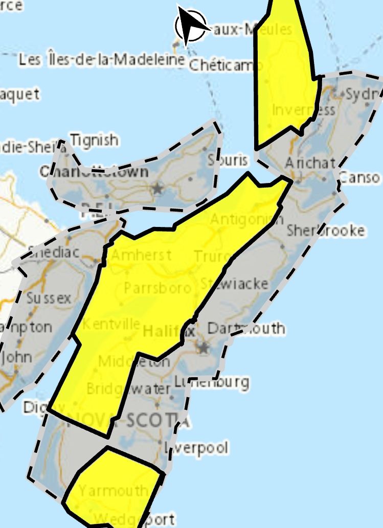
Snowfall warnings have been issued for areas from the Annapolis Valley through northern Nova Scotia and northern Cape Breton
Similarly, rainfall warnings have been issued for Shelburne and Yarmouth counties.
Strong winds may cause tree branches to break and damage utility lines.
Consider adjusting travel plans to avoid the most adverse conditions.
Please continue to monitor alerts and forecasts issued by Environment Canada. To report severe weather, send an email to NSstorm@ec.gc.ca or post reports on X using #NSStorm.
Higher than normal water levels are expected to impact parts of the coast.
Large waves, pounding surf and elevated sea water levels are expected, possibly exceeding high astronomical tide Wednesday morning.
Locations: southeastern facing coastlines from Herring Cove to Shelburne.
Time span: Near high tide Wednesday morning.
Remarks: Storm surge and minor coastal flooding is possible along shorelines exposed to the southeast, especially around high tide.
Shore or beach erosion and damage to coastal infrastructure is possible in vulnerable areas.
Please continue to monitor alerts and forecasts issued by Environment Canada. To report severe weather, send an email to NSstorm@ec.gc.ca or post reports on X using #NSStorm.
Source
https://weather.gc.ca/index_e.html?alertTableFilterProv=NS¢er=44.84735960,-62.86385626&zoom=6
-
Special weather statement remains in effect
Snow, rain, and strong winds are expected.
Potential snowfall: 10 to 15 cm for inland and elevated areas.
Potential rainfall: 30 to 50 mm along the Atlantic coast.
Potential wind gusts: northeasterly 70 to 90 km/h.
Time span: this afternoon until Wednesday afternoon.
Remarks: Precipitation should fall mostly as rain for most coastal areas as temperatures will be a few degrees above zero.
Snowfall warnings have been issued for areas from the Annapolis Valley through northern Nova Scotia and northern Cape Breton
Similarly, rainfall warnings have been issued for Shelburne and Yarmouth counties.
Strong winds may cause tree branches to break and damage utility lines.
Consider adjusting travel plans to avoid the most adverse conditions.
Please continue to monitor alerts and forecasts issued by Environment Canada. To report severe weather, send an email to NSstorm@ec.gc.ca or post reports on X using #NSStorm.
Traffic & Weather
Coastal flooding advisory / Special weather statement remains in effect

**** Via Environment Canada
Coastal flooding advisory
Higher than normal water levels are expected to impact parts of the coast.
Large waves, pounding surf and elevated sea water levels are expected, possibly exceeding high astronomical tide Wednesday morning.
Locations: southeastern facing coastlines from Herring Cove to Shelburne.
Time span: Near high tide Wednesday morning.
Remarks: Storm surge and minor coastal flooding is possible along shorelines exposed to the southeast, especially around high tide.
Shore or beach erosion and damage to coastal infrastructure is possible in vulnerable areas.
Please continue to monitor alerts and forecasts issued by Environment Canada. To report severe weather, send an email to NSstorm@ec.gc.ca or post reports on X using #NSStorm.
Source
https://weather.gc.ca/index_e.html?alertTableFilterProv=NS¢er=44.84735960,-62.86385626&zoom=6
-
Special weather statement remains in effect
Snow, rain, and strong winds are expected.
Potential snowfall: 10 to 15 cm for inland and elevated areas.
Potential rainfall: 30 to 50 mm along the Atlantic coast.
Potential wind gusts: northeasterly 70 to 90 km/h.
Time span: this afternoon until Wednesday afternoon.
Remarks: Precipitation should fall mostly as rain for most coastal areas as temperatures will be a few degrees above zero.
Snowfall warnings have been issued for areas from the Annapolis Valley through northern Nova Scotia and northern Cape Breton
Similarly, rainfall warnings have been issued for Shelburne and Yarmouth counties.
Strong winds may cause tree branches to break and damage utility lines.
Consider adjusting travel plans to avoid the most adverse conditions.
Please continue to monitor alerts and forecasts issued by Environment Canada. To report severe weather, send an email to NSstorm@ec.gc.ca or post reports on X using #NSStorm.
Higher than normal water levels are expected to impact parts of the coast.
Large waves, pounding surf and elevated sea water levels are expected, possibly exceeding high astronomical tide Wednesday morning.
Locations: southeastern facing coastlines from Herring Cove to Shelburne.
Time span: Near high tide Wednesday morning.
Remarks: Storm surge and minor coastal flooding is possible along shorelines exposed to the southeast, especially around high tide.
Shore or beach erosion and damage to coastal infrastructure is possible in vulnerable areas.
Please continue to monitor alerts and forecasts issued by Environment Canada. To report severe weather, send an email to NSstorm@ec.gc.ca or post reports on X using #NSStorm.
Source
https://weather.gc.ca/index_e.html?alertTableFilterProv=NS¢er=44.84735960,-62.86385626&zoom=6
-
Special weather statement remains in effect
Snow, rain, and strong winds are expected.
Potential snowfall: 10 to 15 cm for inland and elevated areas.
Potential rainfall: 30 to 50 mm along the Atlantic coast.
Potential wind gusts: northeasterly 70 to 90 km/h.
Time span: this afternoon until Wednesday afternoon.
Remarks: Precipitation should fall mostly as rain for most coastal areas as temperatures will be a few degrees above zero.
Snowfall warnings have been issued for areas from the Annapolis Valley through northern Nova Scotia and northern Cape Breton
Similarly, rainfall warnings have been issued for Shelburne and Yarmouth counties.
Strong winds may cause tree branches to break and damage utility lines.
Consider adjusting travel plans to avoid the most adverse conditions.
Please continue to monitor alerts and forecasts issued by Environment Canada. To report severe weather, send an email to NSstorm@ec.gc.ca or post reports on X using #NSStorm.